Streams Need Riparian Zones
The many trees and plants in the riparian zone aid in the stabilization of riverbank soil. Much like the steel reinforcement rods found in concrete bridges, trees and plants along streambanks and lakeshores reduce soil erosion by their roots holding the soil together, making it more difficult for waves, currents and runoff to wash the soil away. Plants further prevent erosion by reducing the impact of raindrops on exposed soil. The result is a decreased input of sediment and suspended solids in the stream.
|
Riparian zones help retain floodwater after heavy rains or snowmelts. These streamside wetlands mimic huge sponges absorbing and filtering water, which reduces peakflow levels in streams, and replenishes the groundwater that helps maintain lake levels and stream flows. As runoff water moves through trees and other plants, leaves and twigs, it slows and drops sediment that has been carried along. Since these sediments are deposited on the banks rather than in the streams, floods can actually be bank-building events. This settling process also keeps nutrients from flowing into streams and lakes, permitting plant roots to take up the nutrients that have dissolved in the runoff and soaked into the soil, reducing the amount of pollution flowing into lakes and streams. |
Because the soil is exceptionally fertile,
riparian areas can produce stands of very large trees. This makes them desirable as
timber sources. But because of the crucial functions these trees serve, riparian
areas are not suitable for logging. These areas are sensitive
to other activities and disturbances as well: excessive livestock grazing, agriculture,
road-building, urban development, and recreation. Estimates of the percentage of
riparian areas that have been altered in the United States range from 70-90%.![]() The extent of riparian-area alterations and resulting problems varies throughout
North America, but the areas generally most heavily impacted have been in the...
The extent of riparian-area alterations and resulting problems varies throughout
North America, but the areas generally most heavily impacted have been in the...
| southeastern... | ||
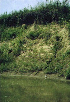 Highly eroded stream bank of Short Creek, Mississippi; Bruce Stallsmith photo |
Streams throughout much of the SE U.S. show such signs of past
logging and poor land use practices. "Massive logging across the southeast is very likely in the next two decades", according to Southeastern Fishes Council Regional Reports - 2000 "We know logging the last 100-year stand in the southeast caused tremendous erosional problems in creeks and rivers...The ensuing erosion was tremendous, particularly in the upper Piedmont where soils are generally very erodible. While modern operations do not use splash dams or cut down every tree, the sheer scope of operations and rate of timber removal will create tremendous stressors on fishes and habitats." |
|
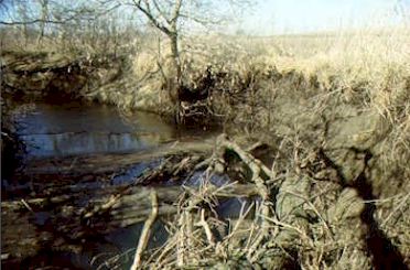
| midwestern... | ||
|
The negative effects of intensive agricultural practices are
visible in streams in the forms of silt, fertilizers and pesticides. Streams then move
these materials to rivers and estuaries and out to the floodplain during high-water
inundation. The nutrients, especially nitrogen and phosphorous, can create locally high nutrient concentrations, low dissolved oxygen levels, pollution and fish kills. This is presently the case in the Mississippi Delta and Chesapeake Bay. One study |
|
| ...and southwestern states. | ||
| Though riparian corridors in the arid western U.S. occupy less
than one percent of the land surface, an estimated 60-70% of western bird species Livestock grazing is considered to be
the greatest source of riparian habitat degradation in the arid regions of the western
U.S. Between 1940 and 1990, the number of cattle in the western U.S. increased from
25.5 to 54.4 million animals |
 San Pedro River, AZ; U.S. Bureau of Land Management photo |
|
| Cattle consume streamside vegetation,
disturb soils, destabilize streambanks, churn up channel sediments, and deposit manure and
urine. One study found that a riparian zone in eastern Oregon comprised only 1.9% of the
grazing area, but produced 81% of the forage consumed by cattle. |
||
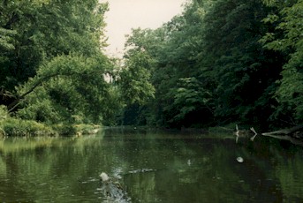
Rivers in northwestern North America...
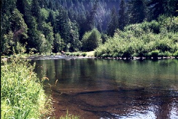 Stable bank with western conifers, clear water and clean gravel define the Siuslaw River, Oregon; Jay DeLong photo |
...have had their own problems resulting from riparian area
destruction through logging and development. Probably no factor has contributed more
to the understanding of the importance of these areas than declining populations of
Pacific salmon.
|
|
|
||
© Robert Carillio s_r_enterprises@hotmail.com and Jay DeLong thirdwind@att.net