Walking in 100-Year-Old Footsteps in Southern Oregon
by Jay DeLong
"Tuesday, Aug 10 Air at 6 A.M. 33o Pretty cold night but slept warm with a bag, canvases, tent fly, etc. Broke camp at 8:30 and drove about 10 mi. to a beautiful trout stream issuing from a spring. Got there at 12:15; Butler at 1:30. Temp. water 54 o. Fine trout in this stream. Hay caught 3 fine ones, I one fine one, and Butler 9. They are the most savage trout I ever saw. They strike with a fluid rush and jump out of the water 2 or 3 times when hooked. The one I caught struck at the grasshopper savagely, missed it, but caught the hook in his opercle. He was very gamey, as was also another much larger one which took the hook and fought quite a while, but finally got loose. Started again at 3:15 and soon came in sight of the Williamson River..." (Personal diary of B.W. Evermann, August 10, 1897; entry recorded while visiting Spring Creek, a tributary of the Williamson River).
Barton Warren Evermann (1853-1932) was a naturalist for the U.S. Fish Commission, the precursor to the U.S. Fish and Wildlife Service and National Biological Service. In 1896 Evermann and five other naturalists conducted surveys of ten locales in Idaho, Oregon and Washington, for the purpose of determining their feasibility for fish culture. Evermann coordinated these surveys, but didn't participate in all of them. He directed S.E. Meek and A.B. Alexander to visit Upper Klamath Lake, Oregon, to determine the success of a 1889 stocking of whitefish into Upper Klamath Lake (where they found out that none of the 400,000 fish had survived to spawn.). Meek and Alexander sampled fish from the lake and reported their observations to Evermann, who published them with Meek in the Bulletin of the United States Fish Commission in 1897. That same year, Evermann himself traveled through the Upper Klamath Lake region and recorded his observations in a personal diary.
One hundred years later, in July 1997, five NANFA members, with a copy of Evermann's diary in hand, celebrated the centennial of Evermann's travels through southern Oregon by visiting the Williamson River and several other sites described in the 1897 diary. Evermann's diary presently resides at the California Academy of Science archives in Sacramento, California. Dan Logan (Santa Rosa, CA) obtained a copy of the diary. Dan spent several years studying the history and fishes of the Klamath River basin, and he was our guide on this trip. Joining Dan were Louise Christensen-Zak (Bothell,WA), Jay DeLong (Olympia, WA), Norman Edelen (Portland, OR) and Lisa Hayashi (Portland, OR).
Natural History of the Klamath Basin
During the last ice age, precipitation and mountain runoff created many large lakes. In Oregon, none was larger than the 1,100 square-mile Lake Modoc, one-million years in the making, and ten times the size of present day Upper Klamath Lake. It was in this ancestral lake, located in what is now northern California and southern Oregon, that the Klamath Basin's famed redband trout, bull trout and suckers evolved. When the climate changed and became drier about 11,000 years ago, Lake Modoc receded, creating many of the basin's lakes, rivers, and valleys. Winter mountain runoff and springs continued to fill the channels and lakes left by Lake Modoc's retreat, enabling them to survive while ones located further east evaporated. Lower Klamath Lake and Tule Lake occupied 125,000 acres in Oregon and CaliforniaŁ-an area almost twice the size of Upper Klamath Lake. Upper Klamath Lake was connected to Lower Klamath Lake. By the time white explorers first arrived, the Klamath Basin, considered a "western Everglades," was a huge expanse of more than 350,000 acres of lakes, rivers, marshes, wet meadows, and seasonally flooded basins.
Up to 80 percent of Pacific Flyway birds used the area during their migrations. The region provided rich and abundant habitat for the 6 million waterfowl that gathered there in the spring and fall. There were so many birds that the Klamath Indians actually made blankets from the feathers. The basin provided vital nesting habitat for waterfowl and colonial nesting pelicans, cormorants, egrets, and herons. In 1908 its importance was officially recognized when President Theodore Roosevelt established the Lower Klamath National Wildlife Refuge as the nations’s first wildlife refuge established specifically for waterfowl.
Early records from the Upper Klamath River Basin indicate the abundance of fish species. Salmon and steelhead were once common in the Klamath Basin, and an observer in 1850 noted that the Klamath River was so choked by salmon that settlers sometimes had difficulties coaxing their horses to ford it. In 1879, E. D. Cope noted that the Lost River sucker "ascends the streams in thousands in the spring, and is taken and dried in great numbers by the Klamath and Modoc Indians", and he noted in 1884 that Upper Klamath Lake sustained "a great population of fishes". C. H. Gilbert wrote in 1897 that the Lost River sucker was "the most important food-fish of the Klamath Lake region", and that spring sucker runs occurred "in incredible numbers". Sucker runs were so numerous that a cannery was established on the Lost River. Several other commercial operations processed suckers into oil, dried fish and other products. Early settlers consumed the suckers and used them for hog feed and fertilizer.
Recent History
Over the past century, more than three-quarters of this great wetlands system has been drained and converted to farmland. Rivers have been dammed, channelized, and altered in other ways. Lakes, streams and marshes have become polluted by sediment and chemical runoff from agricultural and timber lands. Fish species and populations have gone extinct and others are now in imminent danger of doing so.
The Reclamation Act of 1902 initiated the transformation of 235,000 acres of land that was once described as "sunbaked prairie and worthless swamps" into a "broad expanse of lush, green fields." In 1905 the states of California and Oregon ceded the "good land [that] lay wasting beneath the surfaces" to the United States for reclamation, and subsequently, the U.S. Bureau of Reclamation created the Klamath Project to provide land and water for agriculture. They drained wetlands and dammed and diverted rivers and streams. Currently, less than 75,000 acres of wetlands remain in the Klamath Basin.
Six national wildlife refuges now protect some of the most critical wildlife habitats still found in the Klamath Basin. The Bureau of Reclamation estimates that 2Ł4 million birds presently use the Lower Klamath Refuge during fall migration. The U.S. Fish and Wildlife Service places the number lower, around 1 million. Whatever the number, the concentration of birds in the greatly reduced wetland areas is not always healthy, and avian botulism and cholera outbreaks claim 20,000 to 50,000 birds each year.
Today, the U.S. Bureau of Reclamation provides irrigation to about 200,000 acres of farmland and two National Wildlife Refuges in Oregon and California. Because the Refuges were established after the Klamath Project, agricultural needs for water legally take precedence over the needs of the Refuges. The Refuges have been degraded by poor water quality, greatly reduced water quantity, and thousands of acres of fertilizer- and pesticide-intensive commercial agriculture within their borders. More than 11,000 acres of the Lower Klamath National Wildlife Refuge are planted in potatoes, onions, sugar beets, alfalfa, and other crops.
Water quality degradation in the Upper Klamath Lake watershed has led to large-scale fish kills related to algal bloom cycles in the lake. This has probably always been a problem, even prior to farming and ranching in the area. The source of the lake's nutrients was the basin's volcanic soils. Heavy spring runoffs increased sediment loads in the lake and wind blowing across its broad surface created water quality problems by stirring up the sediments that had settled to the bottom. Meek described the lake in 1896 as "very shallow, and the vast amounts of decaying vegetation carried into it and the ever-increasing area of tule lands render it more shallow year by year. The bottom, where we examined it, was composed of loose, disintegrating vegetable material, with no sandy or gravelly bottom." Many people believe that the lake's demise has been accelerated by farming and ranching practices. Studies which examined return flows from pastures along the heavily ranched Wood River Valley revealed phosphorous levels seven to ten times higher than the river's water. Jake Kann, the aquatic ecologist for the Klamath Tribes who performed the study, explained that a cow will produce seven to ten times as much phosphorous as a human. Kann concluded that with Wood River Valley cattle populations somewhere between 50,000 and 100,000, it is the equivalent of having a town with 350,000 people without sewage treatment living along the river.
The nutrient loading in the lake produces immense blue-green algae blooms. Although the lake's algae provides companies like Cell-Tech, of Klamath Falls, with the source for its dietary supplement product and about 540 people with jobs, the lake simply produces far more than can be harvested. When the algae dies, the decaying plant matter decreases the lake's dissolved oxygen and elevates pH levels to 10.0 in some areas. Both of these conditions are lethal to the Lost River and shortnose suckers. To help ensure the survival of these species, the Bureau of Reclamation followed the recommendations of the U.S. Fish and Wildlife Service and established minimum lake elevations in 1992.
Upper Klamath Lake
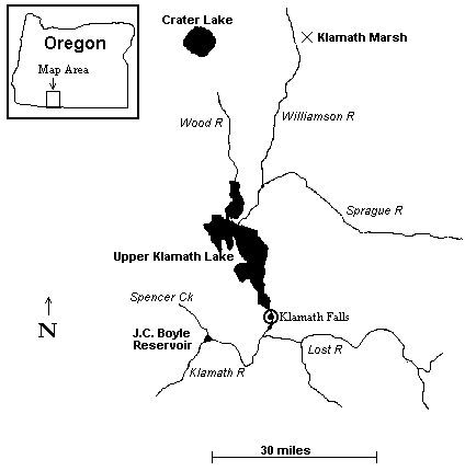
Upper Klamath Lake is a high desert lake (4,300 feet elevation) in south-central Oregon about 30 miles from the California border. The lake is an ecotone, being situated between two very different ecological zones. The heavily-timbered Cascade Mountains (named for their numerous waterfalls) rise immediately to the west and north (Mount Mazama and Crater Lake are a short drive north). To the east and south is arid sagebrush steppe. The lake is approximately 25 miles long with an average width of approximately 8 miles. It is shallow, with an average depth of 8 feet. The town of Klamath Falls is located on the south end at the lake's outlet. The lake drains south into the Klamath River, then into California and out to the Pacific Ocean. Significant rivers in the Upper Klamath Lake basin are shown in figure 1.
Figure 1. Map of Upper Klamath Lake, Oregon, including its major tributaries.
The Williamson River flows from the north. From its headwaters in the north central part
of the basin, it drains into the Klamath Marsh Refuge. There it breaks up into sloughs and
channels while filling the marsh's shallow ponds before continuing southward. Joining the
Williamson as it makes its exit from the Refuge, is Spring Creek. During summer months,
there is usually no discharge from the marsh and Spring Creek maintains the Williamson
until it joins the Sprague River about 10 miles north of the lake. The confluence of the
Williamson and Sprague is Upper Klamath Lake's greatest water source, contributing almost
half of the lake's total annual water supply. A third major tributary, the Wood River,
flows south from the slopes of Mt. Mazama.
Another river of significance to fish and local agriculture is the Lost River. This river, located southeast of the lake, is a sluggish, channelized river connected to the Klamath River via canals downstream from Klamath Falls. The Lost River is a naturally closed sub-basin. It originates at Clear Lake in California and flows in a 90-mile arc back to California and into Tule Lake-Ł only nine miles from its Clear Lake source. Channels and diversion canals control the Lost River's downstream flow and prevent it from flooding reclaimed lands in Tule Lake. This water is channeled into the six miles of Klamath River that lie between Upper Klamath Lake and Keno Dam. Keno Dam also acts to back the Klamath up so that the same channels and canals can be used to replace Lost River waters with those from the Klamath.
Fishes of the Upper Klamath Lake Drainage Basin
Over half the fish species in the Upper Klamath Lake basin are exotic (See Table 1 for a list of the lake’s fishes). Some native species and populations have disappeared, and some are presently threatened with extinction. In 1988, the Lost River and shortnose suckers were declared federally endangered species.
Table 1. Fishes of the Upper Klamath River Basin
| Common Name | Scientific Name | Comments |
| Klamath lamprey | Lampetra similis | native/endemic |
| Miller Lake lamprey | Lampetra minima | native/endemic |
| Pacific lamprey | Lampetra tridentata | native; landlocked |
| Pit-Klamath brook lamprey | Lampetra lethophaga | native |
| white sturgeon | Acipenser transmontanus | exotic |
| brown bullhead | Ameiurus nebulosus | exotic |
| channel catfish | Ictalurus punctatus | exotic; discovered in lake in 1997 |
| rainbow trout | Onchorynchus mykiss | native; two forms: resident redband trout (O.M. newberrii) and an anadromous form landlocked by Klamath River dams |
| bull trout | Salvelinus confluentus | native |
| eastern brook trout | Salvelinus fontinalis | exotic |
| brown trout | Salmo trutta | exotic |
| sockeye salmon | Onchorhynchus nerka | exotic; landlocked (kokanee) |
| mosquitofish | Gambusia affinis | exotic |
| Klamath largescale sucker | Catostomus snyderi | native/endemic |
| Klamath smallscale sucker | Catostomus rimiculus | native |
| Lost River sucker | Deltistes luxatus | native/endemic; Federally endangered |
| shortnose sucker | Chasmistes brevirostris | native/endemic; Federally endangered |
| blue chub | Gila coerulea | native/endemic |
| tui chub | Gila bicolor | native; nomenclature regarding this species is presently being revised |
| speckled dace | Rhinichthys osculus klamathensis | native; Klamath speckled dace |
| fathead minnow | Pimephales promelas | exotic |
| goldfish | Carassius auratus | exotic |
| Klamath Lake sculpin | Cottus princeps | native/endemic |
| slender sculpin | Cottus tenuis | native/endemic |
| marbled sculpin | Cottus klamathensis | native |
| Sacramento perch | Archoplites interruptus | exotic |
| pumpkinseed | Lepomis gibbosus | exotic |
| bluegill | Lepomis machrochirus | exotic |
| green sunfish | Lepomis cyanellus | exotic |
| black crappie | Pomoxis nigromaculatus | exotic |
| white crappie | Pomoxis annularis | exotic |
| largemouth bass | Micropterus salmoides | exotic |
| smallmouth bass | Micropterus dolomieu | exotic |
| yellow perch | Perca flavescens | exotic |
There are presently no anadromous fish in Upper Klamath Lake Basin. Three dams built on
the Klamath River, plus a fish wheel built by the U.S. Fish Commission across the river
(designed to harvest salmon for hatchery broodstock), exterminated runs of chinook salmon,
coho salmon and steelhead.
The lake has three endemic (native to the basin only) suckers, all of which spawn in the lake and its tributaries. Lost River suckers, shortnose suckers, and Klamath largescale suckers spawn in the Williamson River and Sprague River. Lost River suckers and shortnose suckers spawn in the Wood River. Lost River suckers spawn in the Lost River. Lost River suckers and shortnose suckers also spawn in springs of Upper Klamath Lake. Historic spawning runs numbered in the tens of thousands.
Water manipulations threaten Lost River and shortnose suckers with extinction in many ways. The construction in 1914-1918 of the Sprague River Dam eliminated 95 percent of potential spawning areas for Lost River suckers and shortnose suckers in that drainage. Channelization of the lower Williamson River and Wood River may have negatively affected larval survival by reducing rearing and refuge habitat. The historic ranges of Lost River and shortnose suckers have been fragmented by construction of dams, instream diversion structures, and irrigation canals. Because habitat fragmentation limits or prevents genetic interchange among populations, extinction could result as genetic diversity decreases and populations become more susceptible to environmental change. Significant losses to the gene pool of the Lost River sucker may have already occurred with the disappearance of entire stocks and drastic reductions in other populations. In addition, extensive hybridization between Lost River, shortnose, and Klamath largescale suckers has been documented.
Chemical contaminants and over-harvest may contribute to the decline of the suckers. Additionally, introduced exotic fishes may reduce recruitment through competition with, or predation upon, suckers and sucker larvae. The piscivorous channel catfish was just recently discovered in Upper Klamath Lake in 1997.
1997 Explorations
After a long drive we arrived in Klamath Falls around 1 A.M. Friday July 4. We slept for a few hours, then woke early to begin our exploration of the arid sagebrush steppe which was to be our home for the next three days. We knew we'd see fish and other animals we hadn't seen before. During the next three days we visited five sites around Upper Klamath Lake which Evermann mentioned in his diary.
Site 1- Spencer Creek and Klamath River
"Got several snakes (Thammopsis), a toad, a cricket frog and a lizard near Parkers. This place is said to be 32 mi. from Ashland and 31 mi. from Klamath Falls. Air at Parker’s at 3 P.M. 70o. Started again at 3:45 P.M. and drove to Mr. Anderson (13 miles from Parker’s) 18 miles from Klamath Falls or about 1/2 mi. from Spencer Creek. Got there at 7:30 P.M. Good place to camp except dusty. Good water, wood and hay, etc. Did not get to bed till 10 P.M. Air at 9 P.M. 59o. The Klamath River flows in sight of this camp-- across a field to the south." (B.W. Evermann- July 16, 1897).
Evermann didn't look for fish in this dusty area on the south end of Upper Klamath Lake just west of the town of Klamath Falls. He spent his time collecting reptiles and amphibians. We, however, looked for fish. The site where Spencer Creek flows into the Klamath River is now impounded as J.C. Boyle Reservoir, one of the many impoundments throughout the basin that were absent in Evermann’s day. We first sampled a small tributary to the reservoir with a dip-net, finding Sacramento perch, Klamath speckled dace, redband trout, fathead minnows and a juvenile Klamath smallscale sucker or Klamath largescale sucker. We were entertained by a myriad of colorful dragonflies and mountain bluebirds as we collected under the hot July sun.
 52 KB jpg
(Click on thumbnail image to see the larger image)
52 KB jpg
(Click on thumbnail image to see the larger image)
The group at the J.C. Boyle Reservoir tributary
![]() 37 KB jpg
37 KB jpg
Klamath largescale or Klamath smallscale sucker juvenile
 48 KB jpg
Redband trout
We then traveled the short distance to the swift and shallow Spencer Creek, where we used a seine and dip-net to collect redband trout, Klamath lampreys, speckled dace and fathead minnows. We found the lamprey and dace by seining the swiftest riffles, and the trout and fathead minnows were collected in slower, deeper water, and near undercut banks. Dan accidentally demonstrated the effectiveness of a lamprey's mouthparts with the tip of his finger as he tried to position the uncooperative fish for a photo. Ouch! We found fathead minnows almost everywhere we went during our travels. They are a relative newcomer to the basin, and were certainly introduced through releases of fishing bait.
 44
KB jpg
44
KB jpg
Dan and Lisa at Spencer Creek
![]() 73 KB jpg
73 KB jpg
Klamath lamprey
 36 KB jpg
Klamath lamprey mouthparts
Site 2- Lost River
"About 10 miles from Klamath Falls we came upon Lost River which we followed up to Olene. It is a considerable stream having its source in Clear Lake and, after flowing about 80 mi. loses itself in Tule Lake. At Olene it is about 30 feet wide and two to six feet deep. Most of the water in it now really comes from larger springs at Bonanza, 12 miles from Olene. The water is blueish and had a temp. of 67o at 7 P.M. The bottom is of mud and rocks and a good deal of Anacharis grows in the shallows. Mr. Hay and I reached Olene at 3 P.M. and seined some until the other wagon came up. Got the following: Chub Rutilus - common, Agosia - not so, Cottus - common. The blobs were particularly fine. The trout here are said to be very fine. Fished with spinner quite a while for trout but got none." (B.W. Evermann- July 18, 1897).
As we drove to the Lost River we noticed a complex canal system throughout the dry agricultural area east of the lake. The canal system is connected to Upper Klamath Lake and its tributaries. Farmers dam the water flowing through their canal section to flood their fields, an irrigation method used since early this century. They simply stop the flow in their canal section until the water breaches the banks and flows into their fields. This method is preferred by many farmers because they claim spray irrigation is wasteful. A problem with flood irrigation occurs when the fields are over-irrigated and the runoff returns sediment and chemicals to the canal.
We used fishing gear to sample the muddy, sluggish Lost River. In a river once known for its fine trout, we caught yellow perch, largemouth bass, pumpkinseed sunfish and tui chub (Evermann's "Chub Rutilus"). We didn't collect any of Evermann's "Agosia" (Klamath speckled dace), "blobs" (sculpins), or trout. Its flow was very slow, the bottom sediments were mud and silt, and there was abundant aquatic vegetation and floating algal mats. We fished under the starry sky until well after dark and were fortunate to watch a barn owl fly over our heads. We had listened to the owl calling in a large oak for an hour without knowing what it was. Also collecting fish nearby were a great heron and a black-crowned night heron. We returned to our motel in time to enjoy a 4th of July fireworks display over the waters of Upper Klamath Lake.
![]() 36 KB jpg
36 KB jpg
Tui chub
Site 3- Upper Klamath Lake
"…we drove on 4 1/2 miles to Klamath Falls which we reached at 4 P.M. The road here is nearly north and south to the east. Klamath River is in view and when we neared town the little lake (or widening of the river) was in view. Captain O. Applegate says this is properly called Ewauna Lake, meaning the "bend" or "elbow". On it we saw several white pelicans. Crossed the river in the town just above L. Ewauna and made camp…" (B.W. Evermann- July 17, 1897).
Ewauna Lake is a wide spot on the Klamath River at the edge of Klamath Falls. From our motel nearby we also saw white pelicans. We began our second day of exploration at the lake itself and visited several springs where suckers and chubs spawn in the spring. We tried to visualize the lake as it appeared 100 hundred years ago, before the wetlands were drained and filled. One historically-significant spring-fed wetland on the east side of the lake is now Hagelstein Park and its water is reduced to a small channel. We watched yellow-bellied marmots scampering over dry ground where suckers once spawned by the thousands. Further north, we visited Sucker Springs, now reduced to a 50-ft long creek emerging from a culvert. Its short trip to the water was over rip rap and boulders, not the gravel that suckers need to spawn. Amazingly, some suckers, as well as blue chubs, still spawn there, but in low numbers, and their offspring survive poorly.
 63 KB jpg
Dan, Lisa, Norm and Jay in Klamath Falls. See the green grass? That's not natural. What's
natural is the terrain in the background.
We sampled a spot on the shore of the lake called Modoc Point with a seine, collecting tui chubs, blue chubs, marbled sculpins, yellow perch and fathead minnows. The water was full of suspended blue-green algae which looked like grass clippings, and it clogged our seine and made dragging the seine rather arduous. We found a dead shortnose sucker juvenile floating against the shore, and Dan explained that occasional massive kills of the endangered fish occur, due to poor water quality. We tried fishing for trout or large chubs with fishing gear, but quickly gave up because the wind was strong and the water surface was quite choppy. Western grebes and white pelicans fished in the lake along with us, and Norm saw a grebe capture a lamprey.
 50 KB jpg
Lisa and Dan seining the Upper Klamath Lake shoreline. In the upper right just left of the
tree is a commercial algae-harvesting operation at work straining the lake for the
bluegreen algae you find in health food stores.
 28 KB jpg
Try to find a fish among all that algae!
 25 KB jpg
Blue chub
![]() 23 KB jpg
23 KB jpg
Marbled sculpin (a tiny one)
Site 4- Williamson River
"Williamson River, the principal stream flowing into Upper Klamath Lake, is of considerable size and much importance in its relations to the fishes of the lake...It flows before entering the lake through a low, flat, marshy plain covered with tules and swamp grass. On the banks of the river is a rich growth of willows. The current is very moderate. We rowed about 2 miles or more up the river and noticed no important change in it. The water in the river was very dark, evidently stained to some extent by vegetation." (Evermann and Meek (1897)).
"Good camping place on creek inside an Indian's fenced field between his deserted house and creek. Creek a fine stream 25 to 35 feet wide, 4 to 5 foot depth and 1 1/2 foot current. Said to have plenty fine trout. Some people we saw called this the Williamson River, which it may be." (B.W. Evermann- August 8, 1897).
We, too, visited the Williamson River and walked a mile along the slow, dark river to a site called Kirk's Canyon, where we found one of the most idyllic spots any of us had ever seen. Steep rock walls paralleled the meandering river's 300-foot wide valley. The dusty sagebrush desert was gone and we found ourselves in a lush, green valley colored by a multitude of wildflowers. We knew the river upstream flowed through agricultural land and the section downstream was channelized, but we felt for the first time we saw the area as Evermann and Meek had a century before. The river in the canyon was shallow and easily sampled with dip nets and seines. The water was tannin-stained, and the substrate was dark, just as it had appeared to Meek those many years before. The speckled dace we collected there were dark-colored as well. We also collected slender sculpins, tui chubs, redband trout and the ubiquitous fathead minnows.
 73 KB jpg
Kirk's Canyon
 45
KB jpg
45
KB jpg
Speckled dace
![]() 19 KB jpg
19 KB jpg
Slender sculpin
The only unpleasant aspect of this site was the mosquito assault. Before hiking in to the canyon area we all applied insect repellent, but it was so hot that we perspired it off and we had a painful mile-long trek back to our cars. Back at our cars and back in the desert, we heard the howl of coyotes, and we stood listening to them in the suddenly chilly air as the sun set on another eventful day.
Site 5- Klamath Marsh
"Cold night, nearly froze. Got started at 8:30 drove down a creek to Billy Balls’ (about 3 miles) then across his meadow to a yellow pine ridge and to Kellogg’s (Indian) about 8 miles (Indian said 2 1/2!!) where took lunch, then across his meadow and into a yellow pine forest, partially along edge of Klamath Marsh, then through woods and down to the marsh again where we camped. Across the marsh we saw Mt. Scott and Mt. Theilson though the air was very hazy. Mt. Scott has good deal snow. Mt. Theilson none-- too sharp. Klamath Marsh is a wonderful one, large, full of reeds, water-lilies, tules, etc. Waterbirds common…Our camp tonight is a splendid one in all regards except the swamp water." (B.W. Evermann- August 9, 1897)
Klamath Marsh, located 20 miles north of the lake, was the last stop on our trip. In his diary, Evermann sketched (literally) a marsh that no longer exists. The size of the marsh has been reduced over 80 percent, and the only evidence that a marsh once existed in places is the absence of trees. The remnants are now protected as the Klamath Forest National Wildlife Refuge. We didn't look for fish here. Among the "waterbirds" we saw were bald eagles, sandhill cranes, Canada geese, double-crested cormorants, Barrow's goldeneyes, a black-crowned night heron, Caspian terns and black terns. Mule deer and pronghorn roamed the area.
We parted company with Louise here. She drove to Eugene to visit friends and the rest of us headed north. We returned to our homes well after dark on the fourth day of our adventure through time in southern Oregon.
Final Thoughts
I hope you enjoyed my brief account of our trip. I'm sure each of us has our favorite memories. Even the not-so-favorite parts (the constant heat, dust, sunburn, little sleep, truck stop food, and mosquitos) made the experience a memorable one. We enjoyed other activities there, too: digging for fish fossils in the exposed Lake Modoc sediments of a gravel quarry; hunting lizards and snakes in the desert; trout fishing; and visiting a spring gushing from a rock wall with water much too cold to wade in-- even in July in the desert!
Like many, many other areas across the continent, the Klamath Basin is a national treasure that should be preserved. But that wasn’t the prevailing view 100 years ago. Unfortunately, it isn’t today, either. According to the June 1999 Rogue Walker (newsletter of a local Oregon chapter of the Sierra Club), the business community of Klamath Falls is wooing the Tillimook County Creamery Association to build a $20 million cheese plant in the Klamath Basin. The dairy association's president, Harold Shild, has stated that "waste would likely become an issue with the addition of 10,000 cows," but believes the animal waste impact would be small because of the low rainfall in the basin. And in an area already with four golf courses, developers in Klamath Falls, along with professional golfer Arnold Palmer, built a fifth, only 10 miles west of Upper Klamath Lake. It opened shortly after our visit to the area.
However, as I write this in 1999, more than two years since the trip, I see some optomistic items in the news. In drought years, the Bureau of Reclamation has withheld water from farmers and ranchers to assure minimum lake depth, and therefore improve lake water quality, for the endangered suckers. Some people have also proposed removing the Sprague River dam for the purpose of re-opening miles of that river to spawning suckers.
The driving force behind current conservation activities in the basin is the Endangered Species Act. Research funding, challenges to traditional water rights, and changes in land and water management practices have all come about because two fishes were declared endangered species. It is hardly a success story, though, that a species has to be taken to the brink of extinction before it and its habitat receive legal protection. It is clear evidence of our failures to protect our environment. That is why we must continue to insist that not only should the Endangered Species Act be protected, but that we also need laws that protect species and their ecosystems long before any species approach extinction. And these laws must require that we always use the best science available when making decisions affecting our plant and animal life and their ecosystems.
There is an army at our borders. They're going to want land and they're going to consume resources and produce waste in amounts never before experienced. They're our children and their children. According to the U.S. Census Bureau, the world population recently reached 6 billion, and the population of the United States is now 274 million. We positively need to change our lives and find ways to make sure the needs of these future generations are compatible with those of their environment. We owe it to them, and to our environment, to build a national conservation ethic. NANFA members can take a positive role in this by speaking and acting on behalf of our continent’s native fishes and their ecosystems. We need to consider our role in NANFA and in our personal lives as part of a huge public awareness campaign.
References
I borrowed, often heavily, from a number of sources in writing this article. They are:
Cope, E.D. 1879. The Fishes of Klamath Lake, Oregon. American Naturalist 13:784-785.
Cope, E.D. 1884. On the fishes of the recent and pliocene lakes of the western part of the Great Basin, and of the Idaho Pliocene Lake. Proc. Acad. Nat. Sci. Phil. 35(1883):134-167.
Evermann, B.W. and S.E. Meek. 1897. A report upon salmon investigations in the Columbia River Basin and elsewhere on the Pacific coast in 1896. Bulletin of the United States Fish Commission 17:15-84.
Gilbert, C.H. 1897. The Fishes of the Klamath Basin. Bulletin of the U.S. Fish Commission 17:1-13.
Moyle, P.B. 1976. Inland Fishes of California. University of’ California Press. Berkeley, CA. 405 pp.
Scoppettone, G.G. and G.L. Vinyard. 1991. Life History and Management of Four Endangered Lacustrine Suckers. pp. 359-377 in W.L. Minkley and J.E. Deacon (Eds.) Battle Against Extinction: Native Fish Management in the American West. University of Arizona Press. Tuscon and London.
Oregon Water Resources Department. 1999. Resolving the Klamath: Klamath Basin General Stream Adjudication Overview Summary. Salem, Oregon.
U.S. Fish and Wildlife Service. 1993. Lost River (Deltistes luxatus) and Shortnose (Chasmistes brevirostris) Sucker Recovery Plan. Portland, Oregon. 108 pp.